Yellow Weather Alert in Iceland
A yellow alert is in effect for a large part of the country. The Icelandic Met Office
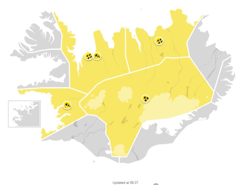
The Icelandic Met Office has issued a yellow weather alert for a large part of Iceland today. The warning is in effect for Faxaflói in Southwest Iceland, for Northwest Iceland, Northeast Iceland and the Central Highlands.
In Faxaflói, the warning is in effect through 10 pm. Northerly winds of 10-18 m/sec are forecast, the windiest conditions in the northern part of the Snæfellsnes peninsula. Wind gusts of 25-30 m/sec. Drivers of campers and vehicles with trailers must exercise caution.
In the Strandir region of the West Fjords and in Northwest Iceland, the warning is in effect through midnight. Heavy rain is expected in Strandir and in the northern part of the Tröllaskagi peninsula, all the way to Siglufjörður. Sleet or snow in the mountains. Swelling rivers are expected, and there is a risk of mud or rock slides.
In Northwest Iceland until 8 pm, a northern gale of 8-15 m/sec is expected, increasing to 10-18 m/sec. Temperatures will range from 2-6° C (26-43° F), but colder in the mountains, where there is a chance of sleet or snow. Please drive carefully.
In Northeast Iceland, there will be heavy rain through 2 pm in the northern parts of Eyjafjörður fjord, but sleet and snow in the mountains. Swelling rivers are expected, and there is a chance of mud or rock slides. Travelers are asked to be cautious.
The weather warning is in effect for the Central Highlands through midnight. North and northwesterly winds of 10-18 m/sec are forecast. Sleet or snow is expected. Temperatures will range between 0 and 3° C (32-37° F). Travelers are advised to exercise caution.
If traveling, please follow the latest weather forecast at en.vedur.is. You can always check road conditions at road.is.


/frimg/1/57/87/1578747.jpg)