Red warnings almost all over the country
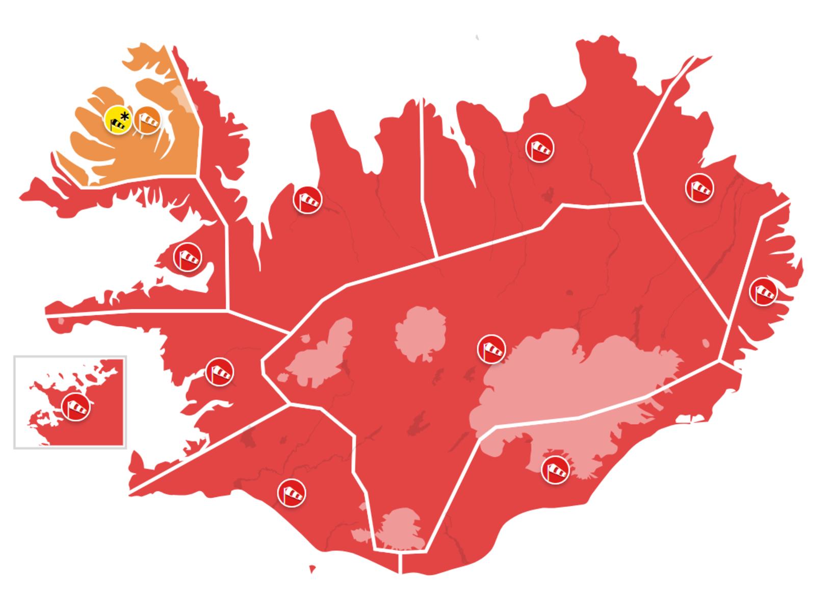
Red warnings have been issued for most of the country. Map/The Icelandic Met Office
Red warnings have been issued for almost the entire country, most of which will take effect this afternoon and again tomorrow morning and the National Commissioner of Police has declared a civil protection emergency.
But what should you be careful of? Here we will review the content of the red warnings according to what the Icelandic Meteorological Office has issued.
It should be borne in mind that orange warnings are in effect until the red ones and also in between. Further information about their content is available on the Icelandic Meteorological Office's website.
Capital Region 4-7 pm today and 8-1 pm tomorrow:
Wind from the south is 28-33 m/s and stronger in wind gusts.
Considerable rain in parts. Wind damage is very likely and it can be dangerous to be outdoors.
No travel weather.
Water levels are rising and higher sea waves.
Southern Iceland at 16-20 today and 8-13 tomorrow:
Wind from the south is 28-33 m/s and gusts locally over 45 m/s. Considerable rain in parts. Wind damage is very likely and it can be dangerous to travel outdoors
High water levels and disruption to transportation are likely. No travel weather. High water levels and wave height can be expected.
Faxaflói 16-19 today:
Wind from the south and southwest is 28-33 m/s and gusts locally over 50 m/s. Considerable rain in parts.
Wind damage is very likely and it can be dangerous to travel outdoors. High water levels and disruption to transportation are likely. No travel weather.
Faxaflói at 8-13 tomorrow:
Wind from the south is 28-33 m/s and gusts over 50 m/s. Rain, considerable for a while.
Wind gusts likely and a look of water surges and disruptions to transportation. No travel weather.
High winds and wave heights can be expected.
Considerable rain and disruptions likely
Breiðafjörður 16-19:
Wind from the south and southwest is 28-33 m/s and gusts locally over 50 m/s. Considerable rain in parts.
Wind gusts are very likely and it can be dangerous to be outdoors. Water surges likely and disruptions to transportation are likely. No travel weather.
Coasts and Northwestern Iceland at 16-20:
Wind from the south and southwest is 28-33 m/s and gusts locally over 50 m/s. Considerable rain in parts.
Wind gusts are very likely and it can be dangerous to be outdoors. Water surges likely and disruptions to transportation are likely. No travel weather.
Coastal and Northwestern Iceland 10-15 tomorrow:
Wind from the south is 28-33 m/s and gusts over 50 m/s. Rain, considerable for a time.
Wind gusts are likely and a look for water surges and disruptions to transportation. No travel weather.
Northeastern Iceland 17-22:
Wind from the south and southwest is 28-33 m/s and gusts locally over 50 m/s. Considerable rain in parts.
Wind damage is very likely and it may be dangerous to be outdoors.
Water damage and disruption to transportation are likely. No travel weather.
Northeast Iceland 10-16 tomorrow:
Wind from the south is 28-33 m/s and gusts over 50 m/s. Rain, considerable for a time.
Wind damage is likely and a look for water damage and disruption to transportation. No travel weather.
Extensive warnings in East Iceland
East Iceland at Glettingur at 18-04 tonight and night:
Wind from the south and southwest is 28-33 m/s and gusts locally over 50 m/s.
Wind damage is very likely and it may be dangerous to be outdoors. Disruption to transportation is likely. No travel weather.
East Iceland at Glettingur at 8-17 tomorrow:
Wind from the south is 28-33 m/s and gusts over 50 m/s. Rain, considerable for a time. Wind damage likely and disruption to transport. No travel weather.
Eastfjords at 20-04 and 7-18 tomorrow:
Wind from the southwest is 28-33 m/s and gusts locally over 50 m/s. Considerable rain in parts.
Wind damage is very likely and it can be dangerous to be travelling outdoors. Water levels and disruption to transport are likely. No travel weather.
High water levels and wave height in Southeast Iceland
Southeast Iceland at 20-02 tonight and night:
Wind from the southwest is 28-33 m/s and gusts locally over 50 m/s. Considerable rain in parts.
Wind damage is is very likely and it may be dangerous to travel outdoors. Flooding likely and disruption to transportation are likely.
No travel weather. High winds and wave heights can be expected.
Central Highlands at 17-01 and 7-16:
Wind from the south and southwest is 28-35 m/s and gusts locally over 55 m/s.
Considerable rain in parts. Wind damage is very likely and it may be dangerous to travel outdoors.
Flooding and disruption to transportation are likely. No travel weather.


/frimg/1/57/87/1578747.jpg)