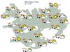
Yellow Weather Alert for Eastern Half of Iceland

Kort/Veðurstofa Íslands
The Icelandic Met Office has issued a yellow weather warning for the central highlands and all the eastern half of the country, effective this afternoon.
For Northeast Iceland, the eastern coastal areas, and the East Fjords, there is a snowstorm warning, effective from 4 pm today through 9 am tomorrow morning (through 5 am for the East Fjords). Winds of 13-18 m/sec are expected, with snow and possibly snowdrift. Poor visibility is expected and difficult driving conditions. Mountain roads may become impassable.
For Southeast Iceland, a northeasterly gale or severe gale warning will be in effect from 2 pm today until 3 am tomorrow. Expect wind speeds of 15-25 m/sec, the strongest wind near Öræfajökull glacier, where wind gusts could exceed 35 m/sec. The strong winds could be hazardous for vehicles.
There is a snowstorm warning for the central highlands, effective from 2 pm today till 9 am tomorrow, where a strong gale from the northeast is expected, with wind speeds of 18-25 m/sec, with snow or snow drift. This weather is not suitable for travel.
The latest alerts and warnings are always listed on safetravel.is, as are travel conditions, conveniently listed on one map.
Before traveling, always check the latest weather forecast on en.vedur.is, as well as road conditions on road.is.
On road.is, you can even check web cams in every part of the country.


/frimg/1/53/30/1533092.jpg)