Thunderstorm and Record Temperatures in Iceland

AFP
A thunderstorm hit East Iceland overnight, according to the Icelandic Met Office. This morning at 6 am, there was still thunder and lightning off the south coast and north of Vatnajökull glacier, and the thunderstorm was thought to potentially reach Eyjafjörður fjord, North Iceland, as well this morning.
Record temperatures for the summer in Iceland measured the second day in a row yesterday, when the daytime high reached 26.9° C (80.4° F) at Hjarðarland in Biskupstungur, South Iceland, and 26.7° C (80° F) by Gullfoss waterfall.
In Ásbyrgi, North Iceland, the temperature reached 25.9° C (78.6° F) on Sunday, which until yesterday was the highest temperature recorded in Iceland for the summer. The warm weather is expected to continue for the coming days.
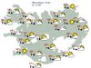
Today, easterly winds will pick up, especially by Eyjafjöll mountains in South Iceland and in Öræfi in the southeast, where wind gusts of up to 25 m/sec are expected. Mountain roads in the West Fjords could also see such windy conditions. Drivers of campers or vehicles with trailers are asked to follow the weather forecast, for these conditions can be hazardous for such vehicles.
Today, there will be showers on the south and southeast coast, fog or drizzle in the East Fjords and in the Strandir region of the West Fjords, but partly cloudy or sunny elsewhere. Highs today will range from 14-20°C. Sunny in most parts of the country tomorrow, with highs of 16-23° C, but 10-15° C in East Iceland.
You can follow the latest weather forecast at en.vedur.is.


/frimg/1/53/30/1533092.jpg)