Glaciers shrunk by 12%
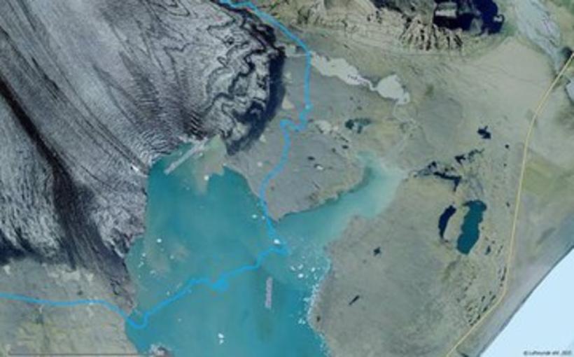
Picture from August 2012 of the edge of Breiðamerkurjökull. The blue line shows the edage of the glaicer in 2001. Photo: Loftmyndir
Icelandic glaciers cover 12% less of the country than previously thought. This is the conclusion drawns from aerial photographs taken by Loftmyndir.
Receding glaciers
According to Karl Arnar Arnarson, Director of Loftmyndir, the company has been renewing its aerial photographs for the last two years.
“The new photos show large-scale changes, as compared to our old photos dating from around 2000,” indicates Arnarson. There are many instances of glaciers having receded by many hundred metres, some even by kilometres.
Official figures out of date
The official figures for the total area of Iceland’s glaciers is 11,922 km2, i.e. 11-12% of the total surface area of Iceland. “These figures quoted in school geography books seem to be based on rather old measurements and it is high time to update them,” says Arnarson. “Hofsjökull, for instance, is officially 925 km2. Images from the Spot satellite in 2006 showed it to have shrunk to 864 km2, while our latest pictures from last summer give it a surface area of 827 km2.” Hofsjökull is therefore over 10% smaller than official figures suggest.
Glacier cover down to just 10%
According to Arnarson Loftmyndir have decided to update the official figures for glacier cover. “The new glacier-cover figures are from summer 2014 and are based on Loftmyndir’s photos and images from the Landsat8 satellite. The total surface area of Iceland’s glaciers in Iceland is now estimated at 10,462 km2, i.e. just 10% of the total surface area of Iceland,” he concludes.
These latest figures are therefore over 12% lower than current official figures.